“How do things touch?” Arie asked. “And,” she paused, absent mindedly nudging dark orange delta sand with her foot, “where do they touch?”
We were walking along the edge of the Ciliwung river in Jakarta. She had been telling me about the recent big-news eviction and demolition of an old neighborhood on the banks. She’d lived there for some time, working in grassroots organizations trying to build networks of mutual-aid between neighborhoods. She’d moved back after finishing graduate school in London. We wandered and caught up.
The banks of the river had been, as city bureaucrats say with a straight face, ‘normalized.’ Canals were being concretized and dredged, residents evicted and their housing demolished. Street fights were erupting between residents and police. Arguments were still unfolding in the courts over the legitimacy of evictions and ownership of riverbank land.
Opposite us was the old neighborhood, now a field of shrapnel and the jetsam of livelihoods.
The roads hum with the pitch of 150cc engines. Men and women don windbreakers, and sometimes gloves and facemasks as protection from the sun and haze. The horns are constant. The roads holey, packed, and always surging.
“The river expands and contracts throughout the year,” she went on. “In the rainy season it bulges, carrying water, sediment, trash, and sewage from upstream hills and neighborhoods. The neighborhoods are catchment areas. Like tributaries but of asphalt. Every surface: roofs, cars, the tops of walls, garbage can lids, everything becomes a conduit when it rains. The river widens its territory.”
“Does a river have a territory?” she asked. “Does it makes sense to talk like that?”
“So when it widens in the rainy season all these houses get flooded. Sometimes for days at a time. People wade around this water. They are no longer on the banks, they are the river. They become sedimentary particles for a few days. When the floods subside they go back to participating in daily life in the ways they normally do. But there is something about this becoming the river then becoming its banks that is really weird. That is, that the people, we’ll, us, living here, oscillate between being the river and its banks. Like we are deposits. Plus, we are also connected and disconnected from people up river. This is a difficult thing to do, to try to make more meaningful connections between neighborhoods here and neighborhoods around the bend. In ways that link us. The river links us. It moves us around, determining how we can operate, how to survive. It’s not we who make that decision. Our fields of action are constantly determined by it. As if it were our unconscious. But it's hard to make up river connections between people."
I jumped up onto the new concrete embankment to walk along it.
The color of the world was orange as it turned towards late afternoon.
Along the side of the road, small hastily constructed restaurants made from wood, metal, and fabric, often with banners for drinks or tobacco used as partitions, shaded inhabitants taking their lunch.
“So what happened with the eviction?” I asked.
“Well, it’s been a long, tiresome, and frightening process. The city decides it needs to demonstrate that it is competent. To give the impression that it is capable of doing stuff. So the first people it goes for are the poor. They are the easiest to move around. They can’t put up much of a fight. And the sign of a flattened neighborhood is evidence of progress. It’s all a big display, a spectacle of change. A crane, even if it just sits there for years, or an elevated expressway column, standing with the re-bar sticking out, is the sign of progress. It’s all about governance as the emission of signs.” She shook her foot to loosen sand lodged in her flip-flop.
“They change the meaning of the river, what belongs to the river and what belongs to them. The banks become the river and so therefore a space of the state, its property. So they can do what they want with it.”
I told her about the bank of the Mississippi River in New Orleans.

In the mid-nineteenth century there was a dispute when a local rich guy bought a bank of the Mississippi: the batture. It was newly created by the river. Its hydraulic action constantly moves sediment from one bank to the other along its entire course. On the inner banks of a bend water moves with greater intensity, on the outside it slows down in the wide swing. In slowing down it can’t carry the same load and deposits sediments, building land. The bend grows inward pushing against the oncoming energy until the river snaps, straightens and starts to meander again. City bureaucrats normalize, rivers meander.
The militarized (and deeply paranoid) colonial fort of New Orleans was set on the outside bank of one of these curves; a high-pressure space with a continent’s worth of sediment bearing down on it. The city grew along the edge of this curve into the swamps, spilling over the natural (and dry) levee of the earliest settlement. With enslaved labor, it drained the swampland. By the mid-nineteenth century the city had developed a dense row of slave plantations along both banks of the river and among the ports’ thriving commodity trade.
The muddy, thin piece of land that was the Batture, was built by the deposition of the river. It was dynamic with the seasons. An enterprising lawyer from New York wanted in (my favorite description of him: “Livingston brought with him to New Orleans an American perspective on property rights, a New Yorker’s eye for the value of riparian land, a debtor’s nose for easy money, and one of the keenest legal minds in the nation”1Richard Campanella, Time and Place in New Orleans: Past Geographies in the Present (Gretna: Pelican Publishing, 2002), 62. He is quoting Ari Kelman’s A River and it’s City: the Nature of Landscape in New Orleans (Berkeley: University of California Press, 2003).). He was promised some section of mud by his friend who owned waterfront property on the condition he took it to court and fought for it to be recognized as private. The opportunities were obvious in the country’s fastest growing city. The court ruled in his favor and he quickly showed up to his new land with laborers and construction material to build a private port. He met a riot. Nothing was built. The pitch battles went on for a Summer. The president was called in and argued in favor of the Batture as public commons. It remained so for years until the legal battle eventually swung in favor of both the lawyer and the public.
The batture was built out by both the river and the residents. It turned into commercial areas, neighborhoods, wharves, and dumps.
And it was no longer a river. But the problem, of course, is that while it flipped into something else it never stopped also being the river: when the spring came and water levels rose parts of the batture flooded. When hurricanes came the river pushed over the sediment barriers, overtopping its banks.
New Orleans and Jakarta are both delta cities made in this strange space between river and land, land becoming river becoming land. They flip back and forth all the time. Sometimes we call that a flood, the wet season, a disaster. But then, we also call it a delta.
This process has almost everything pitted against the hopes and aspirations we imbue in the idea of property. That wants to be fixed for land to stay as land, not to become river. It is supposed to be a little piece of constant onto which we get to pile up hopes for prosperity or at in a liquid world. Antagonists are these two, land and property.
Bluffs
On a Sunday, years ago, we visited the bluffs at the far eastern edge of Toronto. We were on a kind of date, an unspoken one.
There’s an affluent neighborhood of Victorian houses on the shores of Lake Ontario, which is so large it reaches the horizon. One of the houses used to belong to a well-known landscape painter Doris McCarthy who in the mid-twentieth century would set up her easel on the edge of the bluff. Today it is some of the most expensive property in the country. The bluffs reach up to sixty-five meters high, are sandy and regularly loose chunks to the lake currents which churn them up and deposit them on an archipelago of nearby islands. Those islands also have very expensive properties and old families with money. People on the bluffs hate the islanders for growing as they shrink. So they started to build walls out in the lake. Then the islands began to shrink and the islanders to hate those on the bluffs.
At the end of a quiet street we found a little cottage owned by a television personality who had seen some fame in the 1970s. Chatting with a neighbor we learned he’d recently died and left the ownership of his cottage unspecified. This same neighbor also told us about the last biggest slip of the bluff. He’d been sitting on his porch reading the newspaper. It had been raining on and off for days, nothing too unusual for the fall. Then his large beloved willow tree sank into the ground. He watched it. It took two hours. It disappeared uncomfortably like prey into a snake’s mouth. “Did it make a sound?” I asked, to which he replied, “It was mostly silent but the branches brushed the ground. Then sometimes it would crack.” There was nothing to be done. No reversing it. He just sat and watched. “The lake will eventually take our house,” he said. “We’ve probably got a decade, though. I’d say. We’re old, so by that time we might be ready for a nursing home. Go check out old Ken’s place, his went on the same day as the willow. I heard it from here.”
Ken, the old TV star, his small blue clapboard siding cottage from the early 1960s was at the end of a narrow overgrown driveway. As we approached we could see the horizon of the lake through the front of the house. There was no rear wall. The ground had fallen halfway beneath the house. It slumped the structure and forced the wall to pop off. We walked to the new edge of the land. It was jagged like a page torn against the grain. We could see the dinner table still there. Cups and saucers still on the counter. Shredded pink insulation hung out of the poché and shingles draped from the roof. The rest of the debris scattered down the bluff toward the shoreline where the remnants of the willow, now a whitened, denuded log, mixed in with the bits of the house and lake currents.
We talked about decay and how things break and Virginia Woolf. She also loved shorelines as a space of unlikely things touching and turning into each other. The spaces on which stability, beauty, and hopes are projected and into which they can’t hold, broken apart by the intervention of unlikely things, eddies, sediment, the rip of waves.
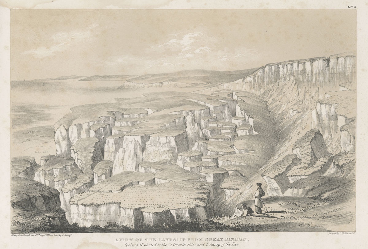
One of the shorelines succumbing to the lake is a few kilometres away from Ken’s house in Lyme Regis; it’s named after the town in the UK with an equally volatile shore. Like the rest of British Upper Canada, Scarborough’s place-names were imported from the old country. See also, London, Peterborough, Kent, Kingston, and Waterloo. Lyme Regis, in Scarborough, is peculiar because it actually looks like the Dorset Coast, only less accessible.
The British Lyme Regis was also an epicenter of the development of ideas about shorelines because of the wealth of fossils exposed by the fragile Jurassic and Triassic aged cliffs. They too constantly fell into the ocean. One notable event occurred on Christmas Eve 1839. The land began to crack in long wavy fissures, slipping down a few feet. People could hear it as it tore. Later that night a large piece of land including pasture and wheat fields split like an iceberg from a glacier and sunk down hundreds of meters into the ocean. It was so heavy that it compressed the land in front of it into an archipelago of islands and earthen columns.
The next day a few geologists visited the site and wrote that the 200-foot cliffs were features of a “beautiful ruin.”
Quoting an unnamed poet, the “crags, mounds, and knolls confusedly hurled presents at once a complete picture of the characteristic features of this broken ground.”2William Conybeare and William Dawson, Memoir and Views of Landslips on the Coast of East Devon &c (London: John Murray, 1840).
The shoreline, rifty with “indentations, and often deep troughs, [earth] pipes… [that] often extend far into the subjacent cherty sandstone,” communicates between layers, mixing them. The “undermining effects of water” had riven through the top layer of earth to the “fox mould” (a local term for sand) below and the clayey under-structure, turning it into the texture of peanut butter. The enormous weight pressing upon it slid down to the ocean.
Accompanying the geologists’ text were drawings rendered in the style popular before Doris McCarthy’s modernism. One that stood out was of two figures getting intimate with the new shoreline. They were in the foreground, small, in the vastness of the dusky, fragmented landscape. One was standing, the other lying on his front with his hands draped over the edge of the cliff. They stared together as if at an amphitheater.
People came from across the country to see the "beauty of the failure." The fields were preserved, still growing wheat, but now in the ocean. Celebratory harvests were held and they sold the products as catastrophe wheat. Word travelled across England. The fissures exposed new fossils of ammonites and fish with feet. People peeled them out of the crevasses and sold them in the fossil shops in town. The catastrophe was linked to the past, as if it were one of a long series. What occurred on Christmas Eve was no exception, it belonged to a depth that was the whole world and all of its past, as if history is a shoreline.
Touch
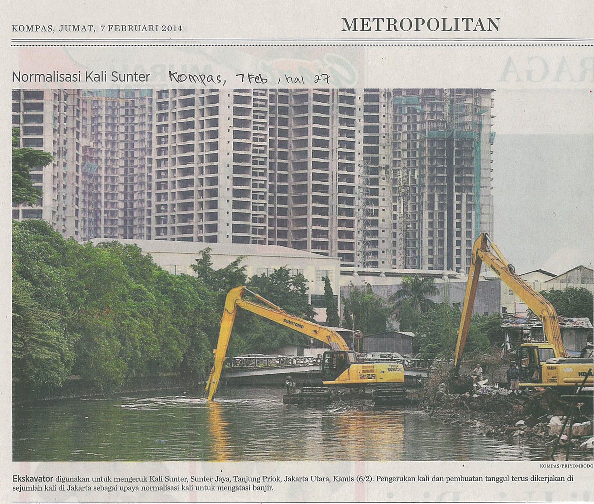
Over a year ago I was walking in Jakarta along the Ciliwung watching the machines and people remake the walls of the banks. I stopped in among a crowd who were all watching, and leaned up against a chunk of concrete, beside me a guy sat on a stool smoking. “What’s happening?” I asked. “Normalization.”
A hydraulic excavator was set on a floating platform. It gnawed at the banks and the river bend, straightening them. On another platform behind it was a pile of six-meter-long white concrete slabs. Behind on a third platform an excavator picked up the slabs with a metal cable. They’d swing in the air like a pendulum counterbalancing the bobbing of the platform on the water. Sometimes they’d swing so far I imagined the loader toppling into the river and a slab ramming into the wrong thing, like us, the spectators nonchalantly watching. The sound of generators beat against the heat and workers directed the slabs into place with their bodies, slowing the swing’s arc with their weight. Some smoked, sitting down, relaxing, with black caps on and flaps guarding their necks against the sun. I pitied the loader drivers. Their expressions made it look as if working that job was an eternal punishment set on a river that never ended, forever struggling against a buoyant machine. Once the slabs were set in place the bucket of the loader would drive them into place like a hammer. Each slab added a meter to the length of the wall in only a half hour. Fourteen meters a day.
No matter the distance, this isn’t about efficiency. It is the spectacle of progress and the building of a new normal, an announcement made in puffs of black generator smoke, the loud pounding of concrete in mud, and fragile bodies.
We all watched as the city was inserted between the river and its banks.
This space between the river and its banks has a brutal history in Jakarta too. When the Dutch first built their (also paranoid) fortified settlement they brought with them hydrological engineering from home. It was originally a murky entanglement of canals and solid ground. Water carried ships in and out loaded with commodities, and waste and sewage flowed out into the bay. It was located at the meeting point of several rivers that drained the volcanoes and hills to the south. This mixture has always stunk. Some of the earliest travelers’ accounts of the place describe how bad it smelled. It was also a malaria den. As the city grew deeper into the delta the canals expanded with it. By the twentieth century, the bulging city was still using the canals for the same purposes. By the twenty-first century the shipping had largely shifted to industrial ports, the population was pushing thirty million and the old canals, barely modified, had to carry all that extra weight. Throughout the rainy season the city was constantly flooding. The riverbanks maintained a legal uncertainty. Who did they belong to? Migrants would fill the banks with cheap housing as a way to jump-start new lives. Some settlements would flourish into complex, longstanding neighborhoods liable to legal recognition under state settlement rights. What was initially infrastructure became property. Or rather, it operated as both at the same time. In the eyes of some it was infrastructure, for others it was home. For many of the urban poor home was simultaneously infrastructure, as if the factory of industrial times had shifted to the canal. Working on, living in, becoming part of the city infrastructure was the new factory floor.
Arie’s two questions: How do things touch? Where do they touch? This is why they’ve stuck: they seem so obvious they must be hiding something profound. The second one is usually where I begin. Is it the whole river or lake that touches the bank? On the Ciliwung, is it the whole of the catchment area, all the way up into the volcanoes in Bandung? Do the volcanoes touch the bank? Are they also the bank? Or is it more discrete.
I’m not sure.
Does it not depend on the scale at which you look and what it is you hope to find? Where does the whole start and stop? Part to whole relationships are mysterious. How much of our talking about a whole is just a result of our laziness, of not knowing how to actually account for the individual relations between parts. Presumably, relations between parts are not the same as they aggregate up in scale.
How do we know that objects don’t supersede their relationships?
The Ciliwung has eddies in its corners that act in ways different to the whole, they transcend it and create a new environment. In that eddy a kid might go harvesting plastic, which he will sell for cash. Parts enter relationships that don’t exhaust their parts. When the relationships perish, like when the kid moves on, the parts remain, the eddy continues to eddy.
How do things touch?
I’ve realized that this question is what I’ve been trying to figure out in Nusantara. I keep coming back, my thinking circling around bodies, rocks and how they touch. Sometimes it’s big rocks; like volcanoes, and how bodies touch them. Sometimes it’s islands, mountains, quarries, and bodies. And all the things that come in between them, that mediate their touching and that transform what bodies can feel and how.
This is the problem of intimacy. That’s what happens when a body touches sand, a volcano, sees it through binoculars, or holds a seismograph. Driving a concrete wall between the river and the bank is a form of intimacy. Pitch battles are forms of intimacy. Private property is a form of intimacy. Intimacy is the attempt to make things touch. It’s only through an intimate act that the river is turned into the bank, only intimacy enacts forms of mediation that allow things to touch in certain ways. Only through intimacy do unlikely things touch.
Seismologists know all about this. My friend Cordula showed me a film she had made showing the hands of seismologists moving while they describe how earthquakes work: they always shove their hands together, fold them and slowly run one underneath the other. And this is supposed to be the mantle of the earth? But it is through this minute and fragile gesture that we are sent to imagining the scale of the planet. This is the act of intimacy, to translate across scales, to bring the scale of our bodies into contact with bigger scales.
That’s the space where something passes. A quantum of sensation that bears in its form and content: contact. Perhaps sense is this contact.
Yet the river never reaches the bank and the river is only the bank.